|
Adventure
Associates

|
As an irrepressibly inquisitive child, I would pore over maps of the great Southern land imagining infinitely white vistas, ice-encrusted shorelines and flocks of bizarre creatures engaged in all manner of noisy rituals.
 Then
this fledgling student of geography, in the grip of idleness, would often
identify the most isolated and unlikely points on the globe, vowing one
day to venture to these invariably far-flung and often wholly inhospitable
lands. Antarctica's treacherous, spiny tendril was one such irresistible
location.
Then
this fledgling student of geography, in the grip of idleness, would often
identify the most isolated and unlikely points on the globe, vowing one
day to venture to these invariably far-flung and often wholly inhospitable
lands. Antarctica's treacherous, spiny tendril was one such irresistible
location.
Like the bristly tail of some giant, prehistoric sea creature, the Antarctic Peninsula thrusts out past the Antarctic Circle, lunging vainly toward its sibling, the Andes, across the infamous Drake Passage. As far as the Antarctic is concerned, the peninsula is the most densely populated location on the continent, sprinkled with vast research bases and minute outposts alike. At the height of the summer season, the human population numbers over 3,000 - not counting tourists. That figure shrinks to less than 1,000 during the intensely chilly winter.
Fast-forward thirty years and that misty dream becomes reality. I'm standing on the bow of a modern ice vessel watching hefty chunks of disintegrating pack ice thud against the hull as we pick our way gingerly through a narrow channel. Lonely groups of Adélie Penguins watch curiously as we inch past, while in the distance, a lone Leopard Seal dives for cover under the flow.
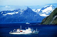 Having
already traversed the waters from The Falkland Islands to South
Georgia and penetrated the snoozing caldera of Deception
Island, the Akedemik Sergey Vavilov and its seasoned crew prepare
to make the perilous entry into the ever-diminishing confines of the frozen
waterways amongst the Palmer Archipelago.
Having
already traversed the waters from The Falkland Islands to South
Georgia and penetrated the snoozing caldera of Deception
Island, the Akedemik Sergey Vavilov and its seasoned crew prepare
to make the perilous entry into the ever-diminishing confines of the frozen
waterways amongst the Palmer Archipelago.
During the pre-dawn,
Vavilov enters the relatively broad expanse of the Gerlache Strait and
well before the first smell of morning coffee wafts up from the galley,
we're perched around the bow, goggle eyed, as the snow-splattered peaks
embracing the Lemaire Channel loom above us. This is the sort of vision
that lasts to the grave - a manic chequerboard of ice chunks, too small
to be called 'bergs' are arrayed out before us. Now at a virtual crawl,
the Vavilov gently nudges them aside, the ice-strengthened steel bow ushering
them delicately around the hull amidst muffled, squeaking protests.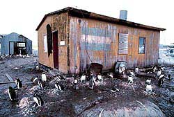
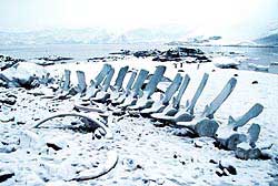
After a suitably reinforcing breakfast we reached our southernmost point, Petermann Island, where a very basic survival hut erected by the Argentines in 1955 provides essential food, shelter and magazines for marooned explorers - handy to know if I miss the last zodiac home. A cross erected nearby bears witness to those who didn't make it. Apart from the curious hut, the little outpost plays host to the southernmost flock of breeding Gentoo Penguins while Sheathbills, Shags and the ever-opportunistic Skuas patrol nearby.
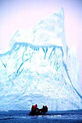 The
return journey was interrupted with some leisurely zodiac cruising amongst
the grounded icebergs off Pleneau Island. Seasoned by a stiff, sleety
breeze, the scene is like a frozen graveyard - these doomed bergs aren't
going anywhere. Arranged in totally random assortments, these guys are
gathered here from all around the peninsula, their normal migration halted
permanently by the shallow harbour. No two even vaguely alike, these forlorn
sculpted slabs still exhibit their marvellous range of intense blue dictated
by varying oxygen density. Our passage is often slowed by a thickening,
smoky pane of ice forming before us and we are forced to bash our way
through with oars as the lightweight zodiac displays its total lack of
ice-breaking capability. Heads suddenly swivel and twitch as a timid female
Leopard seal and pup suddenly appears, and just as mysteriously disappears,
amongst the frosted icescape - a rare sight even for experienced expeditioners.
The
return journey was interrupted with some leisurely zodiac cruising amongst
the grounded icebergs off Pleneau Island. Seasoned by a stiff, sleety
breeze, the scene is like a frozen graveyard - these doomed bergs aren't
going anywhere. Arranged in totally random assortments, these guys are
gathered here from all around the peninsula, their normal migration halted
permanently by the shallow harbour. No two even vaguely alike, these forlorn
sculpted slabs still exhibit their marvellous range of intense blue dictated
by varying oxygen density. Our passage is often slowed by a thickening,
smoky pane of ice forming before us and we are forced to bash our way
through with oars as the lightweight zodiac displays its total lack of
ice-breaking capability. Heads suddenly swivel and twitch as a timid female
Leopard seal and pup suddenly appears, and just as mysteriously disappears,
amongst the frosted icescape - a rare sight even for experienced expeditioners.
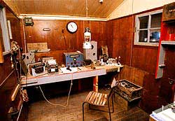
 Next
port of call is the recently refurbished, Port
Lockroy on tiny Goudier Island. Abandoned by the British Antarctic
Survey in 1962, the cute hut is chock full of artefacts from the mid 20th
century's Antarctic expeditions and is now a heritage listed site. A radio
room, a galley and a working post office where you can send a genuine
Antarctic postcard and get your passport stamped. More like monks than
caretakers, Dave and Nigel cheerfully answer questions while dispensing
stamps and souvenirs at the most visited place on the peninsula.
Next
port of call is the recently refurbished, Port
Lockroy on tiny Goudier Island. Abandoned by the British Antarctic
Survey in 1962, the cute hut is chock full of artefacts from the mid 20th
century's Antarctic expeditions and is now a heritage listed site. A radio
room, a galley and a working post office where you can send a genuine
Antarctic postcard and get your passport stamped. More like monks than
caretakers, Dave and Nigel cheerfully answer questions while dispensing
stamps and souvenirs at the most visited place on the peninsula.
 Our
final and most significant landfall is the Chilean mainland base of Gonzales
Videla at Waterboat
Point, where we set foot on Antarctica proper. I suspect our expedition
leader, Julio, a burly Chilean himself, was trying to bolster his country's
economy when I saw the vast array of souvenirs laid out for our inspection.
The table quickly cleared and the contingent hastily withdrew to quantify
their spoils. The location is so named because two typically foolhardy
Englishmen wintered there in 1921-22 in an abandoned Whaler's boat. The
boat itself, oozing history, was burnt by the Chileans as junk. The guano-coated
base is completely overrun by incontinent Gentoo Penguins, all fiercely
protected by the dozen or so military personnel who are quick to interdict
if wandering visitors stray too close.
Our
final and most significant landfall is the Chilean mainland base of Gonzales
Videla at Waterboat
Point, where we set foot on Antarctica proper. I suspect our expedition
leader, Julio, a burly Chilean himself, was trying to bolster his country's
economy when I saw the vast array of souvenirs laid out for our inspection.
The table quickly cleared and the contingent hastily withdrew to quantify
their spoils. The location is so named because two typically foolhardy
Englishmen wintered there in 1921-22 in an abandoned Whaler's boat. The
boat itself, oozing history, was burnt by the Chileans as junk. The guano-coated
base is completely overrun by incontinent Gentoo Penguins, all fiercely
protected by the dozen or so military personnel who are quick to interdict
if wandering visitors stray too close.
 We
salute the Chilean flag that flies above the ashes of the original water
boat, knowing that this will be our last view of the Antarctic mainland.
The aptly named Paradise Bay is the epitome of classic Antarctic Peninsula
scenery. Deceptively tranquil waterways dotted with ice cakes and framed
by snow-dusted cliffs, completely silent except for the occasional screech
of a wheeling seabird.
We
salute the Chilean flag that flies above the ashes of the original water
boat, knowing that this will be our last view of the Antarctic mainland.
The aptly named Paradise Bay is the epitome of classic Antarctic Peninsula
scenery. Deceptively tranquil waterways dotted with ice cakes and framed
by snow-dusted cliffs, completely silent except for the occasional screech
of a wheeling seabird.
I believe we all posses
a photographic memory, and when I close my eyes and recall these evocative
vistas in all their glory, I'm grateful for this small power of the mind.
Occasionally I blow the dust off my weighty old atlas and childishly smile
that certain knowing smile as my eyes pass along what were once simply
maps but are now living, full colour diaries of adventure.
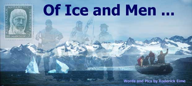
Words and Pictures by Roderick Eime
Where is the Antarctic
Peninsula? - See
The Map
How to Get There - Adventure
Associates
Related Links: BAS
: Scott Polar Research
Institute

|
|
|